Big March storm system threatens US with tornadoes, blizzards and wildfire risk
Big March storm system threatens US with tornadoes, blizzards and wildfire risk
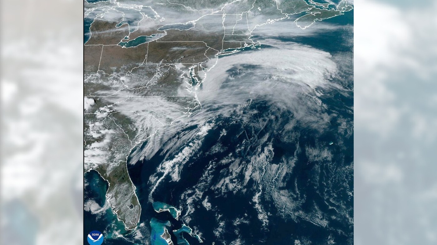
A huge storm system crossing the U.S. threatens to unleash tornadoes Friday in the Mississippi Valley, blizzards in the northern Plains and dry, gusty conditions in Texas and Oklahoma that pose an extreme risk of wildfires.
The National Weather Service predicted extreme weather across a vast swath of the U.S. with a population exceeding 100 million people. Powerful winds gusting up to 80 mph were forecast from the Canadian line to the Rio Grande border with Mexico.
Forecasters say the severe storm threat will continue into the weekend, with a moderate chance of tornadoes and damaging winds pushing farther south Saturday to areas including New Orleans and Birmingham, Alabama. Heavy rain could bring flash flooding to some parts of the East Coast on Sunday.
Experts say it’s not unusual to see such weather extremes in March, when emerging spring warmth and lingering winter cold create big temperature differences for storms to thrive.
“If there’s a time of the year where a storm like this can deliver these coast-to-coast impacts, we are in it,” said Benjamin Reppert, a meteorologist at Penn State University.
A regional outbreak of severe storms was expected Friday afternoon with some risk of thunderstorms extending from the Great Lakes to the Gulf Coast.
Forecasters said tornadoes, damaging winds and hail up to baseball-size were likely, with the greatest risk in eastern Missouri, much of Illinois and portions of Iowa, Kentucky, Tennessee and Arkansas. The weather service’s Storm Prediction Center said 17 million people faced an enhanced to moderate severe storm threat from Des Moines, Iowa, to Jackson, Mississippi.
The tornado threat pushes farther south on Saturday into the Gulf Coast states, including New Orleans and other parts of eastern Louisiana and much of Mississippi and Alabama.
Forecasters warned that heavy snow whipped by powerful winds are likely to make travel treacherous in parts of the Rockies and Northern Plains. Blizzard conditions were possible in the Dakotas and Minnesota.
Winter storm warnings issued Thursday lingered into Friday morning in mountainous regions of Arizona and Utah, where more than a foot (30 centimeters) of snowfall was possible. Forecasters warned of poor visibility and icy road conditions, urging motorists to travel with extra food and water in case they became stranded.
The winter blast continued after snowfall of up to 3 feet (90 centimeters) blanketed the Sierra Nevada earlier in the week.
Warm, dry weather and sustained winds of up to 45 mph brought what the weather service called “near historic” conditions for sparking wildfires Friday to the Southern Plains and parts of the Southwest. Wind gusts exceeding 80 mph were possible.
Forecasters shared a bit of advice during a special briefing: For those stuck on the roads, keep a firm grip on the steering wheel and watch for fallen trees, power lines and other debris. They said the strong winds would be kicking up plenty of dust and that brownout conditions were possible.
“This is likely to be the worst dust storm so far this year,” said Randall Hergert, a lead forecaster with the weather service in Albuquerque.
Forecasters also warned about an extreme risk of fires in parts of northern Texas, much of Oklahoma and southeast Kansas. A broader area where the fire threat was designated as critical stretched from eastern New Mexico into Texas and north to a portion of southern Iowa.
The weather service said a potential for dry thunderstorms in parts of Kansas, Oklahoma, Missouri and Arkansas carry the added risk of fires being started by lightning with minimal rainfall to stop them from spreading.


With Beyoncé's Grammy Wins, Black Women in Country Are Finally Getting Their Due
February 17, 2025


Bad Bunny's "Debí Tirar Más Fotos" Tells Puerto Rico's History
February 17, 2025


Comments 0